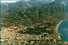
Ancient district and modern department of the southwestern Peloponnese, Greece, bounded on the east by the Taygetus Mountains (Taigetos Oros), on the north by the Nédha Potamos (river) and the Arcadian mountains, and on the south and west by the Ionian Sea. Capital and chief port of the prefecture is the muchsung Kalamata, the land of the Kalamatianos dance and the silk kerchief. Of succulent black olives, honeyed figs and the sesame-covered sweet called pastelli. The town is dominated by the l3th century castle above it built by Geoffrey de Villehardouin. 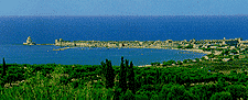 On the north side of the cita- del there is a small Byzantine church, dedicated to the Virgin of Kalomata (of the good eye), from which the town may have acquired its name. From the castle you can survey the expanse of sea below with its sandy and pebbly shores or turn your gaze upon the deep green plain, the "happy land" of the ancients. The old city is spread out underneath the castle. This is where the Byzantine church of the Virgin Ypapanti and the convent of the Kalograies, where the nuns weave the famous Kalamata silk, are situated.
There are many churches in town, the oldest being the historic church of Agioi Apostoli (l3th c.), where the Greek Revolution against the Turks was formally declared on 23 March,1821. Kalamata has an archaeological and folklore museum, a fine arts museum and a library containing 60.000 volumes. Every summer cultural events like concerts and plays put on by the Kalamata theatre are held in the amphitheatre of the castle. In the evening, the town comes alive, especially along the waterfront which is lined with tavernas, seafood restaurants and rotisseries serving local dishes and drinks, fresh fish, roast suckling pig and chicken, sausages, cheese, olives, retsina and raki. From neighbouring Eleia you can already feel the charm of that most cheerful and bountiful of places, Messinia.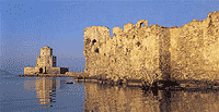 Euripides sung its praises, calling it "a land of fair fruitage and watered by innumerable streams, abounding in pasturage for cattle and sheep, being neither very wintry in the blasts of winter, nor yet made too hot by the chariot of Helios". And this happy situation has continued into our own day. Long, cool summers, the sweetest of springs, gentle autumns, and mild winters, many springs and abundant water, fertile soil, verdant mountains. The first stop is Kiparissia.
The town sits as if wedged into the base of its fortress, its lower districts reaching as far as the sandy shore lapped by the lonian sea. Round about the castle is a plain planted with olive trees and grapevines. The sea opens into an infinite expanse of azure. They say that the wiew of the sunset from the castle is one of the most splendid in the world. Everything here is imbued with history and a fascinating light. Everywhere you look see ancient, Byzantine and Frankish monuments. Peristera is a place a little beyond the village of Raches (5 km. from Kiparissia), where three beehive tombs have been excavated. Filiatra is not far off. The whole district is dotted with churches, Byzantine and Frankish, of a venerable age Gargaliani sits on a lush hillside. Its worth going up to the town to see the view below: a magical carpet of olive trees and vines that stretches to the sea with Marathou- poli and the islet of Proti, the site of a ruined Mycenaean acropolis, in the background.
Hora is built on a hilltop. This village has preserved its old-fashioned appearance - stone houses with tiled roofs and narrow lanes.
 The finds from Nestor's palace and Peristera are on display in the local museum. South of Hora, 4 km. from Englianos, lies the ruined palace of wise Nestor, who took part in the Trojan War and whose city was the second largest in the Mycenaean world. Built in the l3th century BC, the palace was destroyed by fire a century later. Excavations have revealed the remains of a luxurious, two-storey central building and two other auxiliary buildings. The buildings were divided into formal apartments, storage areas for wine and oil, toolsheds and workshops. The central apartements - the throne room with its stuccoed-clay cere- monial hearth and the queen's quarters - were richly decorated with frescoes. In the palace archaeologists discovered thousands of clay pots, a bathroom with ter- racotta bathtub and 1,250 clay tablets with inscriptions in Linear B, which have since been deciphered. Several beehive tombs have been excavated in the area sur- rounding the palace.
From Hora to Pilos the countryside is laid out with row upon row of olive trees, those bene- volent trees protected by Athena. Pilos is a pretty little town built up a hill on the south coast of the bay of Navarino. Snow-white two-storey houses with courtyards drenched in flowers. The arcad- ed streets make you think you've been transported to an island. The main square ringed with pastry shops is sheltered by humongous, centuries-old plane trees. The Turko-Venetian fortress, known as Neokastro, dominates the west side of town. One of the most attractive in the Peloponnese, it is called that to distinguish it from the ancient fortress to the southwest, named Paliokastro or Palionavarino. The bay of Voidokilia extends from the base of the old castle. A tranquil, carefree sanctuary, the floor of the bay is covered with a thick layer of sand.
On the north side of the cita- del there is a small Byzantine church, dedicated to the Virgin of Kalomata (of the good eye), from which the town may have acquired its name. From the castle you can survey the expanse of sea below with its sandy and pebbly shores or turn your gaze upon the deep green plain, the "happy land" of the ancients. The old city is spread out underneath the castle. This is where the Byzantine church of the Virgin Ypapanti and the convent of the Kalograies, where the nuns weave the famous Kalamata silk, are situated.There are many churches in town, the oldest being the historic church of Agioi Apostoli (l3th c.), where the Greek Revolution against the Turks was formally declared on 23 March,1821. Kalamata has an archaeological and folklore museum, a fine arts museum and a library containing 60.000 volumes. Every summer cultural events like concerts and plays put on by the Kalamata theatre are held in the amphitheatre of the castle. In the evening, the town comes alive, especially along the waterfront which is lined with tavernas, seafood restaurants and rotisseries serving local dishes and drinks, fresh fish, roast suckling pig and chicken, sausages, cheese, olives, retsina and raki. From neighbouring Eleia you can already feel the charm of that most cheerful and bountiful of places, Messinia.
Euripides sung its praises, calling it "a land of fair fruitage and watered by innumerable streams, abounding in pasturage for cattle and sheep, being neither very wintry in the blasts of winter, nor yet made too hot by the chariot of Helios". And this happy situation has continued into our own day. Long, cool summers, the sweetest of springs, gentle autumns, and mild winters, many springs and abundant water, fertile soil, verdant mountains. The first stop is Kiparissia. The town sits as if wedged into the base of its fortress, its lower districts reaching as far as the sandy shore lapped by the lonian sea. Round about the castle is a plain planted with olive trees and grapevines. The sea opens into an infinite expanse of azure. They say that the wiew of the sunset from the castle is one of the most splendid in the world. Everything here is imbued with history and a fascinating light. Everywhere you look see ancient, Byzantine and Frankish monuments. Peristera is a place a little beyond the village of Raches (5 km. from Kiparissia), where three beehive tombs have been excavated. Filiatra is not far off. The whole district is dotted with churches, Byzantine and Frankish, of a venerable age Gargaliani sits on a lush hillside. Its worth going up to the town to see the view below: a magical carpet of olive trees and vines that stretches to the sea with Marathou- poli and the islet of Proti, the site of a ruined Mycenaean acropolis, in the background.
Hora is built on a hilltop. This village has preserved its old-fashioned appearance - stone houses with tiled roofs and narrow lanes.
The finds from Nestor's palace and Peristera are on display in the local museum. South of Hora, 4 km. from Englianos, lies the ruined palace of wise Nestor, who took part in the Trojan War and whose city was the second largest in the Mycenaean world. Built in the l3th century BC, the palace was destroyed by fire a century later. Excavations have revealed the remains of a luxurious, two-storey central building and two other auxiliary buildings. The buildings were divided into formal apartments, storage areas for wine and oil, toolsheds and workshops. The central apartements - the throne room with its stuccoed-clay cere- monial hearth and the queen's quarters - were richly decorated with frescoes. In the palace archaeologists discovered thousands of clay pots, a bathroom with ter- racotta bathtub and 1,250 clay tablets with inscriptions in Linear B, which have since been deciphered. Several beehive tombs have been excavated in the area sur- rounding the palace. From Hora to Pilos the countryside is laid out with row upon row of olive trees, those bene- volent trees protected by Athena. Pilos is a pretty little town built up a hill on the south coast of the bay of Navarino. Snow-white two-storey houses with courtyards drenched in flowers. The arcad- ed streets make you think you've been transported to an island. The main square ringed with pastry shops is sheltered by humongous, centuries-old plane trees. The Turko-Venetian fortress, known as Neokastro, dominates the west side of town. One of the most attractive in the Peloponnese, it is called that to distinguish it from the ancient fortress to the southwest, named Paliokastro or Palionavarino. The bay of Voidokilia extends from the base of the old castle. A tranquil, carefree sanctuary, the floor of the bay is covered with a thick layer of sand.
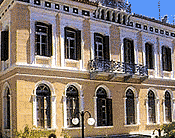
City of Kalamata
The capital of the province of Messinia has 44.052 residents and it is built ïn the eastern part of the inmost part of the Messinian Gulf, at the foot of Mount Taygetos.
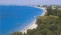
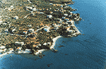
 It extends to a great length and has a Beach of 4 km with crystal clear waters.
It was founded, according to local tradition, in the mid-2nd century A.D. during the Homeric years by Fari, the son of Hermes and Filodameas, and was firstly named Farai while its contemporary name, according to tradition, comes from an icon of the Blessed Virgin Mary, the Kalomata Virgin Mary.
 In the years of the Franks, Kalamata, the basis of the barony, became an important centre of medieval civilization, while in its castle, which had been an acropolis for the ancient Faron and restored by the Franks, the prince and occcupant (1289-1307) of Moreas, Vileardouinos the 2nd (1246-1278), father of the princess Izambo, was born.
During the Turkish rule, it became an important financial centre with Panayiotis Benakis, the most famous of its noblemen, along with the Mavromichalis family from Mani.
Those become the organisers of the Revolution in 1770, the well-known Orlofikon. On the 23rd of March in 1821, the Greek Revolution was declared at the church of St. Apostles against the turkish invader by Petrobeis Mavromichali the bey of free Mani.
Today, Kalamata is a contemporary city which has been rebuilt after the disastrous earthquake on the 13th September 1986.
It has recreation facilities, parks and sports facilities where athletes of individual and team sports prepare in order to take part in international competitions like the weightlifters and the athletics team who won gold medals in the Olympic Games of Atlanda.
There are also congress halls, hotels, marinas, campsites and rooms to rent.
It extends to a great length and has a Beach of 4 km with crystal clear waters.It was founded, according to local tradition, in the mid-2nd century A.D. during the Homeric years by Fari, the son of Hermes and Filodameas, and was firstly named Farai while its contemporary name, according to tradition, comes from an icon of the Blessed Virgin Mary, the Kalomata Virgin Mary.
In the years of the Franks, Kalamata, the basis of the barony, became an important centre of medieval civilization, while in its castle, which had been an acropolis for the ancient Faron and restored by the Franks, the prince and occcupant (1289-1307) of Moreas, Vileardouinos the 2nd (1246-1278), father of the princess Izambo, was born.During the Turkish rule, it became an important financial centre with Panayiotis Benakis, the most famous of its noblemen, along with the Mavromichalis family from Mani.
Those become the organisers of the Revolution in 1770, the well-known Orlofikon. On the 23rd of March in 1821, the Greek Revolution was declared at the church of St. Apostles against the turkish invader by Petrobeis Mavromichali the bey of free Mani.
Today, Kalamata is a contemporary city which has been rebuilt after the disastrous earthquake on the 13th September 1986.
It has recreation facilities, parks and sports facilities where athletes of individual and team sports prepare in order to take part in international competitions like the weightlifters and the athletics team who won gold medals in the Olympic Games of Atlanda.
There are also congress halls, hotels, marinas, campsites and rooms to rent.
Mani
On the southest part of the Peloponnese the impressive and extensive mountain range of Taygetos «intrudes» in the Mediterannean sea and forms the rocky and dry peninsula of Mani.
The first inhabitants, according to the traveller Pausanias, were the Leleges, while during the homeric years it was divided into small kingdoms («polismata»).
 During the roman time the cities of the region, after a request made by Rome, formed the «Public of the Freelakones» in 195 A.D., the ancestors of the contemporary Maniards, to counter the sovereighty of Sparta, while its Byzantine presence was intense during the period 1263-1453 when there was the Despotato of Mystras.
The unsubdued spirit and the faith in freedom inspired the struggle of Maniards against the turkish invader which helped them achieve a special regime of privilege which included internal autonomy, permission to carry weapons but also an obligation to pay annual taxes.
Mani was governed by the beys who had Petrobeis Mavromichalis as a leader who declared the Greek Revolution in 1821 against the Turks.
 In 1826, when Ibrahem Pasha tried to invade Mani, which was the only free area of the Peloponnese, the encountered strong resistance from the Maniates in the area of Verga and he had to retreat.
In the interior, the need for the organisation of the nature and the workforce led to the creation of a self-governed, patriarchal structure while the readiness for war imposed itself as a way of life so that the armed groups of people, who were also related to each other by blood, prevail as basic units in the organisation of both the residential areas and the social as well as financial life.
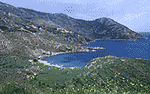
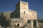
From Avia to Kardamyli and from Stoupa to Itylo, this peculiar place, with the rocky coasts, the enclosed bays which offer peace and quietness, the towers of Many which stand impressively on the dry land, and the woman of Mani (Maniatissa) wife, mother and mistress of her household, challenge the visitor to explore clues from secretly lost and invaluable faces of this land in order to show and spread this peculiar cultural legacy.
Outer Mani stretches from Verga, in the southeast of Kalamata, to Doloi and Kambos where Homer had placed «Iri Poiessa» and «Enopi» which were flourishing cities back then(1580-1120 B.C).
 Iri was where M. Mantinia is today, and was named, after the first doric King of Messinia, Kresfondis, while the archaeological findings prove the existence of a civilization during the promycaenaic and mycaenaic era.
The homeric Enopi, or Gerinia during the classical years, was where Kambos Avias is today and where Nestoras, the king of Pylos carried and buried, in the area Rodon (=rose) the body of Mahaona, the son of Aesculapuis after the Trojan War.
The domed royal «tomb of Mahaona» is in good condition in Garbelia in Kambos.
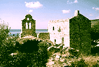
St. Theodores at Kambos, the Convent of Helmos at Gaetses and other Byzantine churches, the towers of Mani of Koutifari -Aloupidon at Malta of Stavropirgio, of Garbelia, at Kambos, where the ex-Prime Minister Alexander Koumoundouros and the Kapetanakis Family were born, at M. Mantinia as well as the castle of Zarnata, are characteristic monuments of the civilization that developed in Outside Mani from the 10th century A.D. to 1821.
The sunny and coastal area of Avia, from Almyros to M. Mantinia and Kitries the ravine of Sandava ends up on the west slopes of Taygetos overlooking the Messinian Guif, constitutes a holiday resort close to Kalamata with pebbly beaches and excellent touristic infrastructure, like rooms to rent and fish tavernas.
Inner Mani stretches from Velona and Prosilio to St. Nikona and includes the valley of Kardamyli and St. Nikolaos as well as the surrounding slopes of Taygetos.
 Kardamyli, the Mycaenaic Lefktro of Mani, Thalames and Pefnos were cities that prospered during the Mycaenaic Era, as it is proved by the archaelogical findings while, during the roman era, they participated in the «Public of the Freelakones» which were financial centres due to their geographical positions.
Kardamyli was a base of the kapetania during the turkish rule and, subsequently, became the base of the bey of Mani, the homeland of Mourtzinos of the Troupakis' family, while the first Bey of Mani Tzanetos Koutifaris was from Thalames.
The twin tombs of Dioskouroi at Kardamyli and the brass statues erected in the harbor of St. Nikolaos, prove the worship of the Dioskouroi in the surrounding area St. Nikolaos at Platsa, St. Sophia and St. Spyridon at Kardamyli, as well as other Christian monuments of the Byzantine era, show the faith of the Maniards to Christianity, while the tower of Mourtzinos at Kardamyli constitutes a sign of the traditional architecture and the organisation of family and social life during the Turkish rule.
The traditional environment, the hospitality of the inhabitants and the natural beauty of the enclosed bays of Fonea, Kalogria, Stoupa, Trahela, and the shelters at the Ravine of Viros are the reasons why Mani attracts so many visitors who seek the harmony between the calm sea and the wild scenery of Mani.
The first inhabitants, according to the traveller Pausanias, were the Leleges, while during the homeric years it was divided into small kingdoms («polismata»).
During the roman time the cities of the region, after a request made by Rome, formed the «Public of the Freelakones» in 195 A.D., the ancestors of the contemporary Maniards, to counter the sovereighty of Sparta, while its Byzantine presence was intense during the period 1263-1453 when there was the Despotato of Mystras.The unsubdued spirit and the faith in freedom inspired the struggle of Maniards against the turkish invader which helped them achieve a special regime of privilege which included internal autonomy, permission to carry weapons but also an obligation to pay annual taxes.
Mani was governed by the beys who had Petrobeis Mavromichalis as a leader who declared the Greek Revolution in 1821 against the Turks.
In 1826, when Ibrahem Pasha tried to invade Mani, which was the only free area of the Peloponnese, the encountered strong resistance from the Maniates in the area of Verga and he had to retreat.In the interior, the need for the organisation of the nature and the workforce led to the creation of a self-governed, patriarchal structure while the readiness for war imposed itself as a way of life so that the armed groups of people, who were also related to each other by blood, prevail as basic units in the organisation of both the residential areas and the social as well as financial life.
From Avia to Kardamyli and from Stoupa to Itylo, this peculiar place, with the rocky coasts, the enclosed bays which offer peace and quietness, the towers of Many which stand impressively on the dry land, and the woman of Mani (Maniatissa) wife, mother and mistress of her household, challenge the visitor to explore clues from secretly lost and invaluable faces of this land in order to show and spread this peculiar cultural legacy.
Outer Mani stretches from Verga, in the southeast of Kalamata, to Doloi and Kambos where Homer had placed «Iri Poiessa» and «Enopi» which were flourishing cities back then(1580-1120 B.C).
Iri was where M. Mantinia is today, and was named, after the first doric King of Messinia, Kresfondis, while the archaeological findings prove the existence of a civilization during the promycaenaic and mycaenaic era.The homeric Enopi, or Gerinia during the classical years, was where Kambos Avias is today and where Nestoras, the king of Pylos carried and buried, in the area Rodon (=rose) the body of Mahaona, the son of Aesculapuis after the Trojan War.
The domed royal «tomb of Mahaona» is in good condition in Garbelia in Kambos.
St. Theodores at Kambos, the Convent of Helmos at Gaetses and other Byzantine churches, the towers of Mani of Koutifari -Aloupidon at Malta of Stavropirgio, of Garbelia, at Kambos, where the ex-Prime Minister Alexander Koumoundouros and the Kapetanakis Family were born, at M. Mantinia as well as the castle of Zarnata, are characteristic monuments of the civilization that developed in Outside Mani from the 10th century A.D. to 1821.
The sunny and coastal area of Avia, from Almyros to M. Mantinia and Kitries the ravine of Sandava ends up on the west slopes of Taygetos overlooking the Messinian Guif, constitutes a holiday resort close to Kalamata with pebbly beaches and excellent touristic infrastructure, like rooms to rent and fish tavernas.
Inner Mani stretches from Velona and Prosilio to St. Nikona and includes the valley of Kardamyli and St. Nikolaos as well as the surrounding slopes of Taygetos.
Kardamyli, the Mycaenaic Lefktro of Mani, Thalames and Pefnos were cities that prospered during the Mycaenaic Era, as it is proved by the archaelogical findings while, during the roman era, they participated in the «Public of the Freelakones» which were financial centres due to their geographical positions.Kardamyli was a base of the kapetania during the turkish rule and, subsequently, became the base of the bey of Mani, the homeland of Mourtzinos of the Troupakis' family, while the first Bey of Mani Tzanetos Koutifaris was from Thalames.
The twin tombs of Dioskouroi at Kardamyli and the brass statues erected in the harbor of St. Nikolaos, prove the worship of the Dioskouroi in the surrounding area St. Nikolaos at Platsa, St. Sophia and St. Spyridon at Kardamyli, as well as other Christian monuments of the Byzantine era, show the faith of the Maniards to Christianity, while the tower of Mourtzinos at Kardamyli constitutes a sign of the traditional architecture and the organisation of family and social life during the Turkish rule.
The traditional environment, the hospitality of the inhabitants and the natural beauty of the enclosed bays of Fonea, Kalogria, Stoupa, Trahela, and the shelters at the Ravine of Viros are the reasons why Mani attracts so many visitors who seek the harmony between the calm sea and the wild scenery of Mani.
