Byzantine State of Mystras
Historic region in the southeastern part of the Peloponnese, southern Greece. The present department of Laconia corresponds closely to the ancient province, which was bounded by Arcadia and Argolis on the north and Messenia in the west. Sparta, capital of the modern department, was once the capital of the ancient province.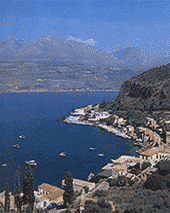 Laconia has three distinctive topographic zones, running north-south and incorporating two of the three peninsulas of the southern Peloponnese: (1) the Taíyetos (ancient Taygetus) Mountains in the west, including Mount Ilías 2,404 m, the highest mountain of the Peloponnese, running south to the promontory of Cape Taínaron at the tip of the isolated Máni peninsula; (2) the central valley of the Evrótas River; and (3) the dissected eastern hills, which rise in the north to 1,935 m in Mount Párnon, terminate at the end of the Maléa peninsula, and reappear in the hills of the offshore islands of Elafónisos and Cythera (Kithira). Laconia's only large rivers are the Evrótas River and its tributary, the Oinoús River.
 The coast, especially in the east, is rugged, with few good harbours. Neolithic sites (before 2500 BC) are found in the Evrótas valley, the Maléa peninsula, and elsewhere; Yeráki, a quiet village southeast of Sparta, has been occupied continuously since Neolithic times and has remains from several periods of its history. In the Late Mycenaean period (1400-1100 BC) numerous settlements were founded; Laconia was a strong kingdom ruled by Menelaus, according to Homer. The Dorian Invasion (about 1100 BC) brought widespread destruction to the Peloponnese, and several centuries passed before Laconia began to reemerge.
 Throughout the classical period, the history of Laconia is that of its capital, Sparta, which at that time was called Lacedaemon. In 195 BC towns on the coast were freed by Rome and became members of the Achaean League, which eventually included all of Laconia. In AD 267 and again in 395, Visigoths devastated Laconia, and in about 587 Slavic incursions brought on two centuries of barbarism. In 805 Laconia became part of the Byzantine Empire, and throughout the Middle Ages it was the scene of struggles between Slavs, Byzantines, Franks, Turks, and Venetians. Tradition holds that the last Byzantine emperor, Constantine Palaeologus, was crowned in the church of Hagios Demetrios, which still stands at Mistrás, just southwest of Sparta. In the Greek War of Independence (1821-29), inhabitants of the Máni peninsula played a prominent part.
The most important archaeological work--apart from that in Sparta, Gythium, and Vapheio--has been the systematic survey of Laconia begun in 1904 by the British School of Athens and continued intermittently. In antiquity the Taygetus range yielded iron and marble, while green porphyry (lapis lacedaemonius) was quarried at Croceae (modern Krokeaí).Hard stones, naked hillsides. Bays and coves torn by the sea and the wind. Men harder than the stones around them. Proud beings, these Maniots. Every so often at the edge of the sea a small hamlet sprouts up. A series of mountain villages higher up. The towers of the Mani are well-known. Made of stone and fearless souls. You see one tower, then another and another. Later heavy silence falls and you see Itillo before you. Deserted beaches for solitary roaming. Opposite stand the ruins of the fortress of Keleta. Fur- ther on beneath a steep cliff lies the little harbour of 28 Limeni. High above looms Taigetos, its peaks forbidding and inaccessible. The haunt of the goddess Artemis. Areopolis. Sharp rocks and white stones. A harsh and remote landscape. It takes its name from Ares (Mars), god of war. Honour and bravery.
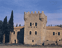
 The courage of the Maniots is le- gendary. Ancestral glory. It echoes through the cobbled alleys of the city and in the corridors of the Kapetanaki Tower (a GNTO guest-house). Pirgos Dirou. Towers everywhere. The most famous of aII is the one belonging to the Sklavounakos family. The Diros caves. Many-splendoured colours. Stalactites and stalagmites form figures in a tight embraceAwe and wonder. Then comes the tiny bay Mezapos, dotted with ruined towers. One looms above them aII from its perch on a hich cliff, the ruined Castle of the Mani, Maina, which gave its name to the peninsula. Nothing here but stones, prickly pears and a few gnaried olive trees. Gerolimenas. Some houses and a pier chockablock with caiques. Rest and relaxation in a friendly tavernaki. Calm and tranquillity. To the north lie the towers of Kita and Nomia. To the south the village of Alika among the prickiy pears. Further on the steep cape of Kiparissos. There was a temple to Poseidon here. The oracle and sanctuary of the Laconians and the temples of Demeter and Aphro- dite. Still further the little road to Marmari and the cave of Hades. Where the descent to the Underworld began. This is the cavern Orpheus braved in his search for the lost Eurydice. Beyond it lies Cape Tenaro or Matapas with its huge lighthouse followed by Porto Kagio, a refuge for quail and storks. (You have to prowl about ceaselessly with the map to find these places or else take the more usual route, a ride around the peninsula by caique). You come to wheat fields and olive trees. Knolls crested with towers.
 City of Ancient Sparta
Modern Greek Sparti, historically Lacedemon, ancient capital of the Laconia district of the southeastern Peloponnese, Greece, and capital of Lakonia on the right bank of the Evrotas Potamos (river). The sparsity of ruins from antiquity around the modern city reflects the austerity of the military oligarchy that ruled the Spartan city-state from the 6th to the 2nd century BC. A brief treatment of ancient Sparta follows. For full treatment, see Greek and Roman Civilizations, Ancient. Reputedly founded in the 9th century BC with a rigid oligarchic constitution, the state of Sparta for centuries retained as lifetime corulers two kings who arbitrated in time of war.  In time of peace, power was concentrated in a Senate of 30 members. Between the 8th and 5th century BC, Sparta subdued Messenia, reducing the inhabitants to serflike status. From the 5th century the ruling class of Sparta devoted itself to war and diplomacy, deliberately neglecting the arts, philosophy, and literature, and forged the most powerful army standing in Greece.
Sparta's single-minded dedication to rule by a militarized oligarchy precluded any hope of a political unification of classical Greece, but it performed a great service in 480 BC by its heroic stand at Thermopylae and its subsequent leadership in the Greco-Persian wars. The Battle of Salamis (480) revealed the magnitude of Athenian naval power and set in motion the deadly struggle between the two powers that ended in Athenian defeat at the close of the Peloponnesian War in 404 and the emergence of Sparta as the most powerful state in Greece. In the Corinthian War (395-387) Sparta had two land victories over Athenian allied states and a severe naval defeat at Cnidus by a combined Athenian and Persian fleet. Sparta's involvement in Persian civil wars in Asia Minor under Agesilaus II (ruled 399-360) and the subsequent Spartan occupation (382) of the Theban citadel, Cadmea, overextended Spartan power and exposed the state to defeat at Leuctra (371) by the Theban Epaminondas, who went on to liberate Messenia.
A century-long decline followed. Sparta's continued agitation spurred Rome's war on the Achaeans (146) and the Roman conquest of the Peloponnese. In AD 396 the modest city was destroyed by the Visigoths. The Byzantines repopulated the site and gave it the ancient Homeric name Lacedaemon. After 1204 the Franks built a new fortress city, Mistra, on a spur of the Taygetus range southwest of Sparta; after 1259 Mistra was capital of the Despotate of Morea (i.e., the Peloponnese) and flourished for about two centuries. From 1460 until the War of Greek Independence (1821-29), except for a Venetian interlude, the region was under Turkish rule. The present-day town was built in 1834 on the ancient site; it is called Nea (New) Sparti locally to distinguish it from the ruins that were excavated in 1906-10 and 1924-29. A small commercial and industrial centre of the Eurotean plain, the city trades in citrus fruits and olive oil. As in antiquity, it is served by the small port of Githion, modern Greek .
In time of peace, power was concentrated in a Senate of 30 members. Between the 8th and 5th century BC, Sparta subdued Messenia, reducing the inhabitants to serflike status. From the 5th century the ruling class of Sparta devoted itself to war and diplomacy, deliberately neglecting the arts, philosophy, and literature, and forged the most powerful army standing in Greece.Sparta's single-minded dedication to rule by a militarized oligarchy precluded any hope of a political unification of classical Greece, but it performed a great service in 480 BC by its heroic stand at Thermopylae and its subsequent leadership in the Greco-Persian wars. The Battle of Salamis (480) revealed the magnitude of Athenian naval power and set in motion the deadly struggle between the two powers that ended in Athenian defeat at the close of the Peloponnesian War in 404 and the emergence of Sparta as the most powerful state in Greece. In the Corinthian War (395-387) Sparta had two land victories over Athenian allied states and a severe naval defeat at Cnidus by a combined Athenian and Persian fleet. Sparta's involvement in Persian civil wars in Asia Minor under Agesilaus II (ruled 399-360) and the subsequent Spartan occupation (382) of the Theban citadel, Cadmea, overextended Spartan power and exposed the state to defeat at Leuctra (371) by the Theban Epaminondas, who went on to liberate Messenia.
A century-long decline followed. Sparta's continued agitation spurred Rome's war on the Achaeans (146) and the Roman conquest of the Peloponnese. In AD 396 the modest city was destroyed by the Visigoths. The Byzantines repopulated the site and gave it the ancient Homeric name Lacedaemon. After 1204 the Franks built a new fortress city, Mistra, on a spur of the Taygetus range southwest of Sparta; after 1259 Mistra was capital of the Despotate of Morea (i.e., the Peloponnese) and flourished for about two centuries. From 1460 until the War of Greek Independence (1821-29), except for a Venetian interlude, the region was under Turkish rule. The present-day town was built in 1834 on the ancient site; it is called Nea (New) Sparti locally to distinguish it from the ruins that were excavated in 1906-10 and 1924-29. A small commercial and industrial centre of the Eurotean plain, the city trades in citrus fruits and olive oil. As in antiquity, it is served by the small port of Githion, modern Greek .
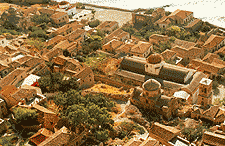
Byzantine State of Mystras
As you approach Mistras (5 km from Sparta) you feel as though you're making a pilgrimage to Byzantine Greece. Going up the hill, you enter through the castle gate, which welcomes you to wander for a while, through the narrow lanes of this once invincible fortress. 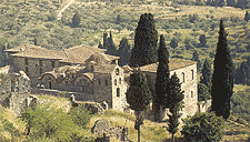 The castle of Mistras was built by the Franks in 1249 in their attempt to establish their supremacy over the Peloponnese. Their catastrophic defeat at Pelagonia (1259) forced them to hand over Mistra to the Greeks. The Frankish prince Guillaume de Villehardouin erected the castle. He built bastions for his knights, houses, dungeons, storerooms, courtyards. From up here he ruled over the world of the Evrotas. As time went by, houses were built on the hillside under the Frankish castle, and a town was born whose fate was to become the centre of civilisa- tion and the cradle of the last dynasty of the Byzantine emperors. The houses roundabout are of two or three storeys. With their imposing vaulted roofs and arcades these mansions lead up to the Palace, an architectural creation of the Palaiologues.
 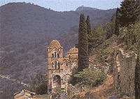 The throne room, the chapel with its vestiges of Byzantine frescoes, the rooms lighted by large windows with ogival arches, are some of the features of this building whose construction took place in various periods, according to the style prevalling in Constantinople. During its two centuries of Mistras' existence as the Byzantine capital of the Peloponnese many churches and monasteries with domes and chapeis were erected, representing aIi the painting trends of the capital. The most important monument you meet on your way up - and the first to be built - is the Cathedral of Agios iìmitrios. On the floor of the church is the two-headed eagle, symbol of the Palaiologos dynasty, carved into a plaque. According to tradition, this is where Konstantinos stepped when he was crowned King. Next to it stands the carved throne. In 1449, Konstantinos Palaiologos was crowned emperor of Byzantium and he left Mistras for Constantinople. In 1453 the Turks captured Constantinople, and a few years later, in 1460, the same fate befell Mistras. Mistras, the brilliant capital of the Despotate of the Morea, was reduced to an insignificant village. The frescoes in the Cathedral show a shining sky painted by skilfull hands. One wing of the church houses the Museum. Towards the northern corner of the enclosure stand Mistras' two most impressive churches, Agioi Theodori and the Panagia Odigitria, known as the Afentiko. Its wall paintings hold you spellbound. Near the highest gate of the castle stands the church of Agia Sofia, while on the slope to the east is the Panta- nassa monastery, built by the lords of the l5th century.
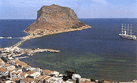
 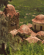 The church is impressive in its elegance and refinement. Its frescoes are filled with bright colour and movement. The Pantanassa today is a hospitable convent with clean cells looked after by gentle nuns, the only living beings in Mistras. Strolling through the narrow lanes of the dead city, you finally come to the Perivlepto, the monastery built under a rock with marvellous frescoes. It is from here that the ascent to the castle begins. Winding stair- ways, arcades, coutyards. Everything in ruins: crumbling facades, turrets with ravaged opening, damaged plaques, decayed mansions. At some point you reach the bare part of the mountain. Below you stretches the endless valley. In front of you a steep path leads to the top of the hill. In an impregnable position, its ramparts and fortification impose themseives on the landscape. The security this castle offered in the face of foreign and local enemies permitted its bishops, lords, enlightened clerics, founders of schools of philosophy, monks, artists, writers and other men of intellect, like Pachomius, Nikephoros Moschopoulos and Gemistos Plethon to transform this town, "protected by God", into a cradle of the Re- naissance. Southeastern Laconia The farthest finger of the Peloponnese. The Laconic guif on the west, the Mirtoo sea on the east. Along both coasts and at some distance from the sea there are scattered villages. One beach after another and then another even larger. Everything baked by the sun and basted by the sea. On the southern coast of the peninsula, looking onto the Mirtoo sea, stands the former Byzantine-Venetian fortress-state of Monemvassia, on its rocky promontory. From afar it looks as if it could be an island. In Greek Monemvassia means one entrance: the long causeway joining it to the mainland was and is the only access to the roc.
The castle of Mistras was built by the Franks in 1249 in their attempt to establish their supremacy over the Peloponnese. Their catastrophic defeat at Pelagonia (1259) forced them to hand over Mistra to the Greeks. The Frankish prince Guillaume de Villehardouin erected the castle. He built bastions for his knights, houses, dungeons, storerooms, courtyards. From up here he ruled over the world of the Evrotas. As time went by, houses were built on the hillside under the Frankish castle, and a town was born whose fate was to become the centre of civilisa- tion and the cradle of the last dynasty of the Byzantine emperors. The houses roundabout are of two or three storeys. With their imposing vaulted roofs and arcades these mansions lead up to the Palace, an architectural creation of the Palaiologues. The throne room, the chapel with its vestiges of Byzantine frescoes, the rooms lighted by large windows with ogival arches, are some of the features of this building whose construction took place in various periods, according to the style prevalling in Constantinople. During its two centuries of Mistras' existence as the Byzantine capital of the Peloponnese many churches and monasteries with domes and chapeis were erected, representing aIi the painting trends of the capital. The most important monument you meet on your way up - and the first to be built - is the Cathedral of Agios iìmitrios. On the floor of the church is the two-headed eagle, symbol of the Palaiologos dynasty, carved into a plaque. According to tradition, this is where Konstantinos stepped when he was crowned King. Next to it stands the carved throne. In 1449, Konstantinos Palaiologos was crowned emperor of Byzantium and he left Mistras for Constantinople. In 1453 the Turks captured Constantinople, and a few years later, in 1460, the same fate befell Mistras. Mistras, the brilliant capital of the Despotate of the Morea, was reduced to an insignificant village. The frescoes in the Cathedral show a shining sky painted by skilfull hands. One wing of the church houses the Museum. Towards the northern corner of the enclosure stand Mistras' two most impressive churches, Agioi Theodori and the Panagia Odigitria, known as the Afentiko. Its wall paintings hold you spellbound. Near the highest gate of the castle stands the church of Agia Sofia, while on the slope to the east is the Panta- nassa monastery, built by the lords of the l5th century. The church is impressive in its elegance and refinement. Its frescoes are filled with bright colour and movement. The Pantanassa today is a hospitable convent with clean cells looked after by gentle nuns, the only living beings in Mistras. Strolling through the narrow lanes of the dead city, you finally come to the Perivlepto, the monastery built under a rock with marvellous frescoes. It is from here that the ascent to the castle begins. Winding stair- ways, arcades, coutyards. Everything in ruins: crumbling facades, turrets with ravaged opening, damaged plaques, decayed mansions. At some point you reach the bare part of the mountain. Below you stretches the endless valley. In front of you a steep path leads to the top of the hill. In an impregnable position, its ramparts and fortification impose themseives on the landscape. The security this castle offered in the face of foreign and local enemies permitted its bishops, lords, enlightened clerics, founders of schools of philosophy, monks, artists, writers and other men of intellect, like Pachomius, Nikephoros Moschopoulos and Gemistos Plethon to transform this town, "protected by God", into a cradle of the Re- naissance. Southeastern Laconia The farthest finger of the Peloponnese. The Laconic guif on the west, the Mirtoo sea on the east. Along both coasts and at some distance from the sea there are scattered villages. One beach after another and then another even larger. Everything baked by the sun and basted by the sea. On the southern coast of the peninsula, looking onto the Mirtoo sea, stands the former Byzantine-Venetian fortress-state of Monemvassia, on its rocky promontory. From afar it looks as if it could be an island. In Greek Monemvassia means one entrance: the long causeway joining it to the mainland was and is the only access to the roc. Castle of Monemvasia
Monemvasia occupies a steep, rocky islet connected to the Laconian coast by a bridge. The settlement was founded in the 6th century A.D. by the inhabitants of Laconia.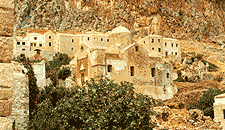 A second settlement was later founded on a lower level, and gradually developed into a town of significant strategic importance. After a short domination of the Popes, the area was captured by the Venetians in 1464. In 1540 it was occupied by the Turks and its decline became more evident. In 1690 it was given over to the Venetians and in 1715 was recaptured by the Turks. It was the first among the fortified towns of the Peloponnese to be liberated by the Greeks in 1821.
The 5th Ephorate of Byzantine Antiquities has reconstructed the demolished parts of walls in the Upper Town and has restored the church and the wall paintings of Aghia Sophia. In the Lower Town, the sea wall has been rebuilt, the Moslem Mosque has been restored, the east and west bastion of the fortification wall have been consolidated, and many of the churches have been repaired and restored.
The most important monuments of the site are:
 The settlement: it is divided into two sections, built at different levels, each with a separate fortification. Remains of numerous Byzantine and post-Byzantine buildings are preserved in the area of the Upper Town which is not inhabited today.
Church of Aghia Sophia (Holy Wisdom) at the Upper Town:
Lower Town: The area is inhabited today and many of the ruined buildings have been restored by the 5th Ephorate. The settlement is surrounded by a U-shaped fortification wall with two gates, one on the east and one on the west side, and a small exit to the sea.
Important monuments of the Lower Town are:
Church of Christ Helkomenos (Led to the Passion): Domed, three-aisled basilica with a barrel-vaulted roof, a narthex, a built synthronon, and an episcopal throne. Significant portable icons of the post-Byzantine period are preserved in the interior.
Moslem Mosque: It was built in the first period of the Turkish occupation (16th century), was converted into a Frankish church during the Venetian occupation, and again became a mosque in the 18th century. It has been restored and houses the Archaeological Collection of Monemvasia.
Church of Panaghia (Our Lady) Myrtidiotissa: Single-aisled, domed basilica built in ca. 1700. The interior was decorated with a wooden carved screen.
Church of St. Nicholas: Three-aisled basilica with a dome and a barrel-vaulted roof, built in 1703.
Church of Panaghia (Our Lady) Chrysaphitissa: Square room roofed with a low dome, built in the 17th century. Many smaller churches are to be seen in the Lower Town of Monemvasia: St. Andrew, St. Anne the Catholic, St. Anne, dated to the second Venetian occupation (1690-1720), St. Demetrios and several more. Octagonal, domed, cross-in-square church, identified by some scholars as the Monastery of Our Lady Hodegetria, dated to 1150.
A second settlement was later founded on a lower level, and gradually developed into a town of significant strategic importance. After a short domination of the Popes, the area was captured by the Venetians in 1464. In 1540 it was occupied by the Turks and its decline became more evident. In 1690 it was given over to the Venetians and in 1715 was recaptured by the Turks. It was the first among the fortified towns of the Peloponnese to be liberated by the Greeks in 1821.The 5th Ephorate of Byzantine Antiquities has reconstructed the demolished parts of walls in the Upper Town and has restored the church and the wall paintings of Aghia Sophia. In the Lower Town, the sea wall has been rebuilt, the Moslem Mosque has been restored, the east and west bastion of the fortification wall have been consolidated, and many of the churches have been repaired and restored.
The most important monuments of the site are:
The settlement: it is divided into two sections, built at different levels, each with a separate fortification. Remains of numerous Byzantine and post-Byzantine buildings are preserved in the area of the Upper Town which is not inhabited today.Church of Aghia Sophia (Holy Wisdom) at the Upper Town:
Lower Town: The area is inhabited today and many of the ruined buildings have been restored by the 5th Ephorate. The settlement is surrounded by a U-shaped fortification wall with two gates, one on the east and one on the west side, and a small exit to the sea.
Important monuments of the Lower Town are:
Church of Christ Helkomenos (Led to the Passion): Domed, three-aisled basilica with a barrel-vaulted roof, a narthex, a built synthronon, and an episcopal throne. Significant portable icons of the post-Byzantine period are preserved in the interior.
Moslem Mosque: It was built in the first period of the Turkish occupation (16th century), was converted into a Frankish church during the Venetian occupation, and again became a mosque in the 18th century. It has been restored and houses the Archaeological Collection of Monemvasia.
Church of Panaghia (Our Lady) Myrtidiotissa: Single-aisled, domed basilica built in ca. 1700. The interior was decorated with a wooden carved screen.
Church of St. Nicholas: Three-aisled basilica with a dome and a barrel-vaulted roof, built in 1703.
Church of Panaghia (Our Lady) Chrysaphitissa: Square room roofed with a low dome, built in the 17th century. Many smaller churches are to be seen in the Lower Town of Monemvasia: St. Andrew, St. Anne the Catholic, St. Anne, dated to the second Venetian occupation (1690-1720), St. Demetrios and several more. Octagonal, domed, cross-in-square church, identified by some scholars as the Monastery of Our Lady Hodegetria, dated to 1150.
