Mountainous region of the central Peloponnesus of ancient Greece. The pastoral character of Arcadian life together with its isolation partially explains why it was represented as a paradise in Greek and Roman bucolic poetry and in the literature of the Renaissance.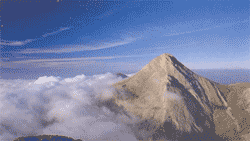 The region is not exactly coextensive with the present-day department, Arkadia, which has an area of 4,419 square km and extends on the east to the Gulf of Argolis; the capital of the department is Tripolis. The plateau of Arcadia, with basins at elevations of 500 to 1,000 m, is bounded on the north by the Erimanthos and Killini mountains and is itself divided by numerous subsidiary ranges. In eastern Arcadia the ranges enclose a series of plains drained only by underground channels. The western plateau is more open, with isolated mountains through which wind the Alpheus River and its tributaries. One of those, the Ládhon, provides hydroelectric power at a dam and reservoir. A region of erratic rainfall, Arcadia has a few vineyards but no olive trees. There are patches of oak forest, but the eastern reaches are drier and less verdant.
 In ancient times Arcadia was bounded on the north by Achaea, on the south by Messenia and Laconia, on the east by Argolis, and on the west by Elis.It was thus cut off from the coast on all sides. Because it was isolated from the rest of mainland Greece, Arcadia was not occupied by the Dorians during their invasion of Greece (1100-1000 BC), and it retained a dialect that still resembles that of the Greeks who settled in Cyprus (the Arcado-Cypriot dialects). By 550 BC Tegea, Mantinea, and the smaller Arcadian towns had all accepted forced alliances with Sparta, and discord between the towns subsequently prevented them from uniting against Spartan power. Most Arcadians remained faithful to Sparta during the Peloponnesian War (431-404 BC), though in 370 BC the Arcadian League, with its capital at Megalopolis, united the Arcadians for a few decades before internal discord paralyzed their confederation.
In Roman times Arcadia fell into decay. It was a scene of conflict during the War of Greek Independence (1821-29). The land of Arcadia Leonidion, sea and lush plain. Old mansions with court- yards and high walled gardens. Houses with symmetrical windows and skylights. Artfully designed chimneys. Painted shutters. Decorated doorways. Stately houses with wood-panelled floors and moulded ceilings. As you stroll around you feel tradition coming alive with your every step in this lovely town. Holy Saturday in Leonidion. The bells toll in a festive way. Firecrackers hiss and bang in the streets non-stop. "Judas" figures burn outside the churches. Noise, com- motion.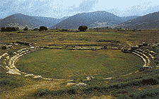 Lights are carried from one neighbourhood to another.The skies aglow with the beams of countless lanterns. On Easter Sunday the festivities reach their peak. Roast meat, wine, sweets, fritters, offered free to aII comers. Locals and strangers. A gesture of traditional gentility.This is Leonidion. Nobility, sunshine, gardens loveliness and generosity. Further on there's Plaka, a chacming little port with a pebbly beach. Shining next to the sea.
To the south, Poulithra, with its old stone houses and marvellous beaches. To the north, little bays. Sabatiki, Livadi quaint unforget- table fishing hamlets. Tiros beach. An enormous expanse of sand and gleaming pebbles. Relaxation and warmth. Just above it the beach of Agios Andreas. Dazzing azure seas. Fishing caiques and tavernas. Sky, sea and land in endless serenity. Paralia Astros. White on a green and blue background. A verse from a poem. Blue and the slap of oars on the water. Shady trees and traditional restaurants. The sweet smell of grilling octopus. A fisherman is untangling his net on the wharf. From here the road branches off to the mountains, Mt. Parnon. The drive is exciting, the countryside wild and unspoilt. Tiny viilages, farmhouses. Platanos, Prastos, Agios Petros. Cottages, manor houses towers and monasteries. The monasteries of Loukou, Elonas, Palaiopanagia Eortakousti, Karia, John the Forerunner. Awesome, silent and strangely comforting. Lighted candles and faint frescoes.
The region is not exactly coextensive with the present-day department, Arkadia, which has an area of 4,419 square km and extends on the east to the Gulf of Argolis; the capital of the department is Tripolis. The plateau of Arcadia, with basins at elevations of 500 to 1,000 m, is bounded on the north by the Erimanthos and Killini mountains and is itself divided by numerous subsidiary ranges. In eastern Arcadia the ranges enclose a series of plains drained only by underground channels. The western plateau is more open, with isolated mountains through which wind the Alpheus River and its tributaries. One of those, the Ládhon, provides hydroelectric power at a dam and reservoir. A region of erratic rainfall, Arcadia has a few vineyards but no olive trees. There are patches of oak forest, but the eastern reaches are drier and less verdant. In ancient times Arcadia was bounded on the north by Achaea, on the south by Messenia and Laconia, on the east by Argolis, and on the west by Elis.It was thus cut off from the coast on all sides. Because it was isolated from the rest of mainland Greece, Arcadia was not occupied by the Dorians during their invasion of Greece (1100-1000 BC), and it retained a dialect that still resembles that of the Greeks who settled in Cyprus (the Arcado-Cypriot dialects). By 550 BC Tegea, Mantinea, and the smaller Arcadian towns had all accepted forced alliances with Sparta, and discord between the towns subsequently prevented them from uniting against Spartan power. Most Arcadians remained faithful to Sparta during the Peloponnesian War (431-404 BC), though in 370 BC the Arcadian League, with its capital at Megalopolis, united the Arcadians for a few decades before internal discord paralyzed their confederation. In Roman times Arcadia fell into decay. It was a scene of conflict during the War of Greek Independence (1821-29). The land of Arcadia Leonidion, sea and lush plain. Old mansions with court- yards and high walled gardens. Houses with symmetrical windows and skylights. Artfully designed chimneys. Painted shutters. Decorated doorways. Stately houses with wood-panelled floors and moulded ceilings. As you stroll around you feel tradition coming alive with your every step in this lovely town. Holy Saturday in Leonidion. The bells toll in a festive way. Firecrackers hiss and bang in the streets non-stop. "Judas" figures burn outside the churches. Noise, com- motion.
Lights are carried from one neighbourhood to another.The skies aglow with the beams of countless lanterns. On Easter Sunday the festivities reach their peak. Roast meat, wine, sweets, fritters, offered free to aII comers. Locals and strangers. A gesture of traditional gentility.This is Leonidion. Nobility, sunshine, gardens loveliness and generosity. Further on there's Plaka, a chacming little port with a pebbly beach. Shining next to the sea. To the south, Poulithra, with its old stone houses and marvellous beaches. To the north, little bays. Sabatiki, Livadi quaint unforget- table fishing hamlets. Tiros beach. An enormous expanse of sand and gleaming pebbles. Relaxation and warmth. Just above it the beach of Agios Andreas. Dazzing azure seas. Fishing caiques and tavernas. Sky, sea and land in endless serenity. Paralia Astros. White on a green and blue background. A verse from a poem. Blue and the slap of oars on the water. Shady trees and traditional restaurants. The sweet smell of grilling octopus. A fisherman is untangling his net on the wharf. From here the road branches off to the mountains, Mt. Parnon. The drive is exciting, the countryside wild and unspoilt. Tiny viilages, farmhouses. Platanos, Prastos, Agios Petros. Cottages, manor houses towers and monasteries. The monasteries of Loukou, Elonas, Palaiopanagia Eortakousti, Karia, John the Forerunner. Awesome, silent and strangely comforting. Lighted candles and faint frescoes.
City of Tripolis
Tripoli is the capitol of the prefecture of Arcadia. Built on an elevation of 665 meters in a basin surrounded by the mountain ranges Menalon 1981m, Aremisio1772m, Parnona 1935m and other smaller mountains. The population of the city is 22,463 in addition to another 3,969 people that live in the outskirts of the city. The city is a center of the Peloponnese in transportation, administration and culture.
The city's geographical position in the center of the Peloponnese makes it ideal for accessing all regions easily for business and pleasure. Tripoli and Arcadia are not tourist destinations with great heritage and areas of extreme beauty.
The 166klm from Athens are made pleasant via an excellent national road that climbs through the artemision mountain actually going through a mountain tunnel of 1600 m. The journey is safe and comfortable and takes about one and a half hours.The city is beautiful with well kept parks, pedestrian streets in the old center and many neoclassical structures that withstood the destruction caused by Ibrhim in 1825. Today it is a modern city that is ever expanding.
The Municipal courthouse has a special place in the city. Before it unfolds the main Areos Square that is proud to have the statue of Theodoros Kolokotronis leader of the Greek forces in the revolution of 1821. All around a lush green park offers shade and recreation.
Areos Square is home to many cultural events, walks and recreation, coffee, food and a place for children to play. All this in a calm environment away from the noise of the bigger cities. Walking through the pedestrian Kalavriton street we come across the other pedestrian streets of the city where many of the cafes and bars are located. This is where the young people of the city meet.
The circular square of st Basiliou is the center of town and where the 4 major streets of the city intersect.
Nafpliou st which leads to the National rd Kalamon st which leads towards Megalopoli, Kalavriton which leads to Olymbia and Vitina and Ethnomartiron leading to the Panarcadian Hospital and the Menalon villages of Stemnitsa-Aalonistena.
From the square of st Basiliou towards Kalamon after 200 m we come to Baltetsiou square where every Saturday a large farmer's market takes place with very good quality local products are sold by local growers. A few meters from st Basil square, in a beautiful neoclassical building, is the War Museum.
On the outskirts of the city next to a large pine forest is the Panarcadian Hospital. The major benefactors of the Panarcadian Hospital are the Greeks who live abroad. After the Pan Arcadian Hospital the road continues through a beautiful pine forest on the way to the historical villages of Alonistena, Libovisi, Dimitsana, Stemnitsa, Chrisovitsi…
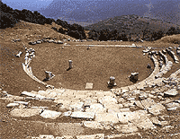
Returning again to the center of town near the st Bail square is the Archaeological museum of Tripoli. Housed in a wonderful Neoclassical building it is one of the best museums in all of Greece not only for its artifacts but also for its organization. Reference texts, floor plans to many sites, and photos from digs, as well as artifacts from tha Ancient Arcadian Civiliation are all a testament to the work of director Dr. Th. Spiropoulos.
Between the squares of st Basil and Kolokotronis is another neoclassical building which used to house the Girls' School . Today it is home to the Municipal Library with over 20,000 volumes of text.
Following Kalavriton rd. which leads to the beautiful village of Livedioiu , on the edge of town is the Athletic center with facilities for track & field, basketball, tennis, swimming and gymnastics.After the Athletic center turning left on Kalvriton Rd. is the wonderful park of St Georgiou . There is a playground, a cafe , zoo, and plenty of space for walking, playing, and sport.
Also during the summer months on the same site, the open air theater is home to many performances and happenings organized by the Artistic Acts Center.
The city's geographical position in the center of the Peloponnese makes it ideal for accessing all regions easily for business and pleasure. Tripoli and Arcadia are not tourist destinations with great heritage and areas of extreme beauty.
The 166klm from Athens are made pleasant via an excellent national road that climbs through the artemision mountain actually going through a mountain tunnel of 1600 m. The journey is safe and comfortable and takes about one and a half hours.The city is beautiful with well kept parks, pedestrian streets in the old center and many neoclassical structures that withstood the destruction caused by Ibrhim in 1825. Today it is a modern city that is ever expanding.
The Municipal courthouse has a special place in the city. Before it unfolds the main Areos Square that is proud to have the statue of Theodoros Kolokotronis leader of the Greek forces in the revolution of 1821. All around a lush green park offers shade and recreation.
Areos Square is home to many cultural events, walks and recreation, coffee, food and a place for children to play. All this in a calm environment away from the noise of the bigger cities. Walking through the pedestrian Kalavriton street we come across the other pedestrian streets of the city where many of the cafes and bars are located. This is where the young people of the city meet.
The circular square of st Basiliou is the center of town and where the 4 major streets of the city intersect.
Nafpliou st which leads to the National rd Kalamon st which leads towards Megalopoli, Kalavriton which leads to Olymbia and Vitina and Ethnomartiron leading to the Panarcadian Hospital and the Menalon villages of Stemnitsa-Aalonistena.
From the square of st Basiliou towards Kalamon after 200 m we come to Baltetsiou square where every Saturday a large farmer's market takes place with very good quality local products are sold by local growers. A few meters from st Basil square, in a beautiful neoclassical building, is the War Museum.
On the outskirts of the city next to a large pine forest is the Panarcadian Hospital. The major benefactors of the Panarcadian Hospital are the Greeks who live abroad. After the Pan Arcadian Hospital the road continues through a beautiful pine forest on the way to the historical villages of Alonistena, Libovisi, Dimitsana, Stemnitsa, Chrisovitsi…
Returning again to the center of town near the st Bail square is the Archaeological museum of Tripoli. Housed in a wonderful Neoclassical building it is one of the best museums in all of Greece not only for its artifacts but also for its organization. Reference texts, floor plans to many sites, and photos from digs, as well as artifacts from tha Ancient Arcadian Civiliation are all a testament to the work of director Dr. Th. Spiropoulos.
Between the squares of st Basil and Kolokotronis is another neoclassical building which used to house the Girls' School . Today it is home to the Municipal Library with over 20,000 volumes of text.
Following Kalavriton rd. which leads to the beautiful village of Livedioiu , on the edge of town is the Athletic center with facilities for track & field, basketball, tennis, swimming and gymnastics.After the Athletic center turning left on Kalvriton Rd. is the wonderful park of St Georgiou . There is a playground, a cafe , zoo, and plenty of space for walking, playing, and sport.
Also during the summer months on the same site, the open air theater is home to many performances and happenings organized by the Artistic Acts Center.
